Europe's Copernicus adds wildfire detection to satellite browser
European Space Agency integrates real-time fire tracking into free satellite imagery tool as wildfires surge across continent.
Conversation activity · last 3 days peak 3/hr
Summary, timeline and people extracted by Claude from 15 items across 5 sources · 6h ago. Quotes are verbatim.
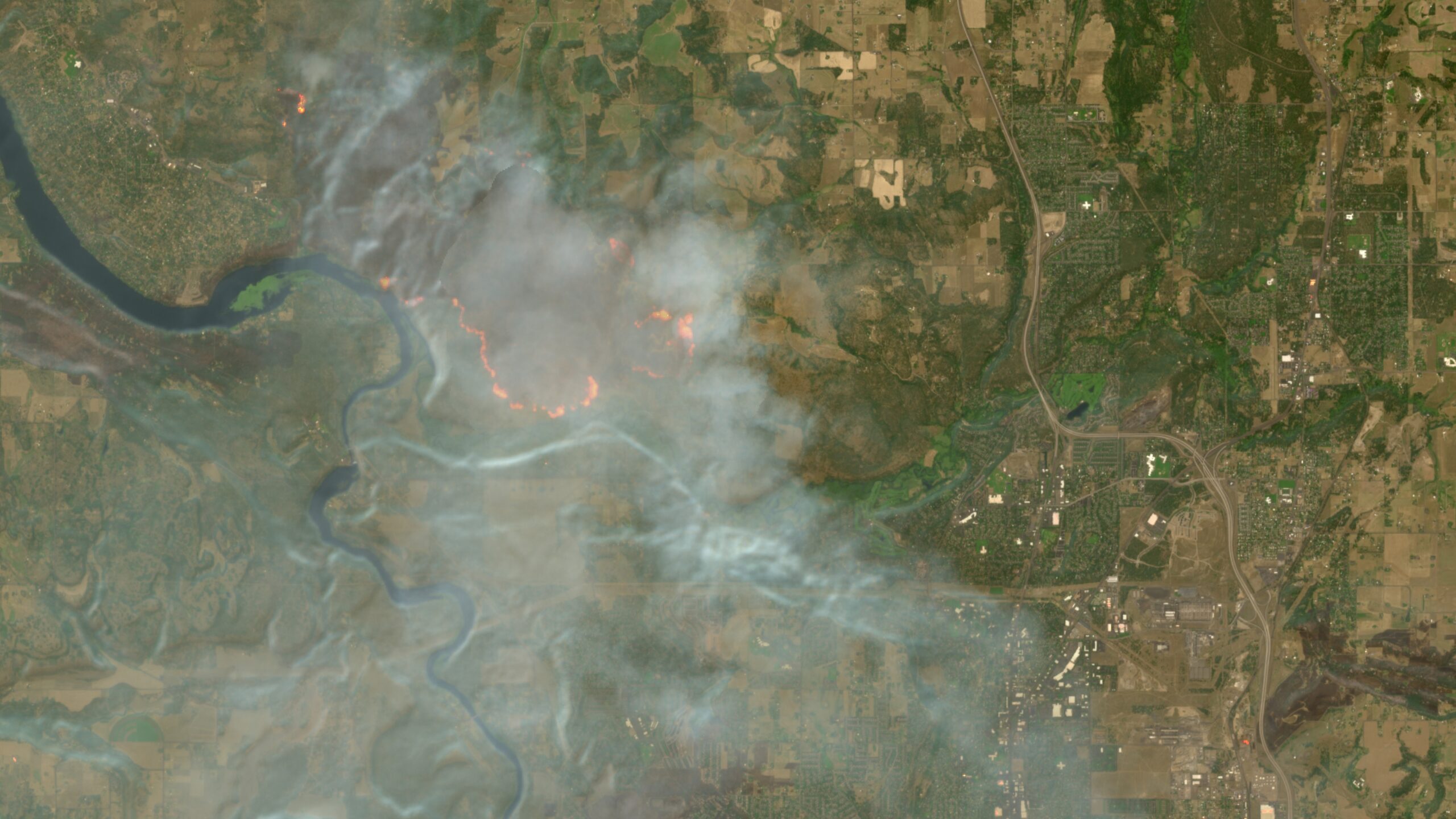
The European Space Agency's Simon Proud has successfully integrated a wildfire detection script into the Copernicus Browser, making it easier for users to track fires using Sentinel-2 satellite imagery without manual configuration. The tool offers 10-meter resolution updates every few days, surpassing NASA's coarser 250-meter resolution FIRMS tool. The integration comes as Europe faces record wildfire seasons, with Greece, France, Spain, and North America all experiencing significant fire activity intensified by climate change.
- Copernicus Browser now integrates wildfire detection as a default feature, making free high-resolution satellite fire tracking more accessible than NASA's FIRMS tool.
- Sentinel-2 satellite imagery provides 10-meter resolution updated every few days, compared to NASA's 250-meter resolution, making it superior for detailed wildfire monitoring.
- Europe faces record wildfire seasons across France, Spain, Greece, and North America, with satellite technology playing an increasingly critical role in early detection and life-saving response.
- Early fire detection via satellite allows emergency services to respond faster, potentially preventing disasters like the 2018 Mati, Greece fire that killed over 100 people.
How it unfolded
-
Reaction Users celebrate improved satellite wildfire tracking
Bluesky user expresses enthusiasm about Copernicus making it easier to use satellite imagery for wildfire tracking.
“Really happy to see Copernicus is making it easier to use satellite imagery to track wildfires.”
faineg.bsky.social · Bluesky ↗ -
Reaction Hacker News discusses Copernicus integration
Ars Technica story gains 165 points on Hacker News with 14 comments, highlighting the tool's superiority to NASA's FIRMS in resolution while noting broader wildfire crises in North America and Europe.
-
Event Copernicus Browser integrates wildfire visualization
Simon Proud, mission scientist for Sentinel-2 at the European Space Agency, announces integration of wildfire detection script into Copernicus Browser as a default option, announced in a Bellingcat Discord channel.
“That makes it arguably the best free and publicly available tool for delivering higher-resolution satellite imagery of everything from wildfires to war zones.”
Ars Technica · Hacker News ↗ -
Report PBS reports on satellite wildfire technology in Greece
PBS NewsHour reports that Greece is using satellite technology to help fight a vicious wildfire season, with Colonel Zisoula Ntasiou emphasizing early detection's importance for saving lives and property.
“if we cut the fires in the early detection, we will cut it in the beginning. So, if we have more time, we can save properties. We can save lives. We can save the forest.”
Col. Zisoula Ntasiou · Bluesky ↗ - 14 weeks quiet
-
Event Greece launches dedicated fire-detection satellites
A rocket deployed four dedicated satellites that constantly scan the Greek landscape for hot spots with the potential to become conflagrations, positioned 360 miles above Earth.
What people are saying verbatim
“That makes it arguably the best free and publicly available tool for delivering higher-resolution satellite imagery of everything from wildfires to war zones.”
Ars Technica article, Technology publication · Ars Technica ↗ · Aug 7
“if we cut the fires in the early detection, we will cut it in the beginning. So, if we have more time, we can save properties. We can save lives. We can save the forest.”
Col. Zisoula Ntasiou, Vice President, International Association of Fire and Rescue Services · PBS NewsHour ↗ · Aug 6
“I don't remember working in a Hellenic Fire Service the last 25 years and thought when I began my career that the space will help us to extinguish fires.”
Col. Zisoula Ntasiou, Vice President, International Association of Fire and Rescue Services · PBS NewsHour ↗ · Aug 6
“The only thing that you could hear was the wind and the fire reaching each one of us, and after other screams, the screams of help, the screams of terror, and the last screams of people who were dying of getting burned.”
Kalli Anagnostou, President, Association of Relatives of the Deceased and Burn Victims (2018 Mati fire) · PBS NewsHour ↗ · Aug 6
“Really happy to see Copernicus is making it easier to use satellite imagery to track wildfires.”
faineg.bsky.social, Bluesky user · Bluesky ↗ · Aug 8
“By comparison, the Sentinel 2 satellite imagery is updated every few days but provides much higher resolution imagery in certain bands down to a 10-meter spatial resolution.”
Ars Technica article, Technology publication · Ars Technica ↗ · Aug 7
Voices from the web unedited
-
New satellites are being used in Greece to help fight another vicious wildfire season.
-
Really happy to see Copernicus is making it easier to use satellite imagery to track wildfires.