Study quantifies Roman road network, finds Constantinople more central than Rome
A Nature Communications analysis of the empire's ~300,000km road system shows provincial capitals, not Rome, were the best-connected hubs.
What to know
- A Nature Communications study built a spatially detailed dataset of the Roman Empire's ~300,000 km road network and analyzed its structure quantitatively for the first time.
- The analysis finds Rome itself was not the most central point in the road network — provincial capitals like Ankara, London and Corinth, and later Constantinople, were better positioned for administration and mobility.
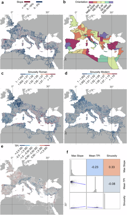
- Roman roads were straighter than typical pre-modern routes where terrain permitted, but less straight than modern roads, and their density correlates with today's major highways in many regions.
“Rome itself was centrally located on the roads on the Tyrrhenian coast of Italy. But when we consider all movement within the entire Italian peninsula, we were shocked to discover that the most central road actually follows the opposite Adriatic coastline, bypassing Rome altogether.”
Tom Brughmans, classical archaeologist, Aarhus University · Channel News Asia ↗ · Sep 14
Tom Brughmans Classical archaeologist, Aarhus UniversityAugustus First Roman emperorConstantine Roman emperor
How it unfolded 2 developments, newest first · click a bar or a number to jump articlesposts
-
2
Study circulates on Hacker News and Mastodon
The Nature Communications paper was shared and discussed on Hacker News and reposted on Mastodon, extending pickup of the CNA and Google News coverage into tech and social discussion spaces.
“We show that Roman roads tend to be straight where topography allows but less so than modern roads; provincial capitals were more centrally located than other cities for mediating terrestrial mobility; segments hypothesised to be main roads were more important intermediaries than secondary roads; and Roman road density correlates with major modern roads.”
— study authors, researchers, Nature Communications paper · source -
 E
E
https://www. europesays.com/3262280/ Ancient Rome Built 190,000 Miles Of Roads And Researchers Just Traced Them All # italy
-
-
1
Brughmans explains findings on Rome's centrality and road durability
Coverage detailed the study's conclusions: Constantinople fit the 'all roads lead to Rome' maxim better than Rome, provincial capitals like Ankara, London and Corinth were exceptionally well placed within their provinces, and Roman road density correlates with modern highway routes in many regions.
“All roads lead to Rome? Not really. Rome is centrally located for Mediterranean shipping, but not particularly central in the Roman road system.”
— Tom Brughmans -
first by New Scientist, 8d ago · also Live Science, Yahoo, Channel News Asia, Straits Times
4 more headlines
- Did 'all roads lead to Rome'? New study finds other cities in the empire were better connected. Live Science · 8d ago
- Study shows marvels of the Roman Empire's road network Yahoo · 8d ago
- ‘Not all roads lead to Rome’: Study shows marvels of the Roman Empire’s road network Straits Times · 8d ago
- Not all roads lead to Rome: Research challenges what we think we know about Roman roads Phys.org · 8d ago
-
-
background
Nature Communications publishes Roman road network study — A team including Tom Brughmans of Aarhus University released a spatially detailed, Empire-wide dataset and quantitative analysis of the Roman road system, covering roughly 300,000 km of routes across Europe, North Africa and the Middle East.
Also covered reported alongside — the timeline has no entry for these yet
-
first by Smithsonian Magazine, 3d ago · also Jalopnik, Smithsonian
1 more headline
and 1 smaller piece